The Ouseburn is a familiar and much loved feature of East Newcastle which, for much of its course, forms the boundary between Heaton / High Heaton and Sandyford / Jesmond. But how many of us knew that another burn once meandered through the township? Until recently, historic maps provided the only readily accessible documentary evidence of the stream. Recently, however, aerial photographs, which really bring the lost landscape to life, have come to light. They were taken in the 1920s before the building of the North Heaton bungalow estate and are reproduced here courtesy of English Heritage.
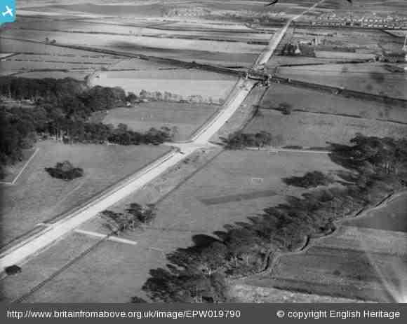
This first picture clearly shows the tree-lined burn on the bottom right. You can estimate its position relative to today’s streets by reference to the railway line, the cemetery wall on the left and the original Coast Road running through the picture. There are few signs of any buildings but football goalposts can be seen just north of the stream. The furthest of the two treelined roads this side of the railway line is what is now Benfield Road.
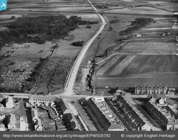
This photograph was taken on the same day, 20th October 1927. Older Victorian houses on Chillingham Road can be seen in the foreground. They still stand today, the block with Solomon’s Lounge Indian restaurant at one end and a dental practice at the other. Opposite this row is Norwood Avenue, again still standing. Music dealer J G Windows was living there when this photo was taken. The houses nearest the present Coast Road were demolished when the road was widened.
The walled Heaton and Byker Cemetery is clearly visible on the left and in front of it what look like allotments (but please get in touch if you know better) where Hilden Gardens is now. Not only were the bungalows south of the Coast Road not yet built – they followed in the 1930s – but neither were the post-war Wills factory or Crosslings (formerly Smiths Crisps). There is, however, a house and possibly some farm buildings in the middle distance on the right. Judging from where Benfield Road meets the railway line, they could be round about where Danby Gardens meets Redcar Road or Debdon Gardens?
We will feature more aerial photos of Heaton and High Heaton on this site over the coming months but in the meantime you can see some in the Old Heaton Group on the Britain From Above website. You can add comments and point out features of interest.
Historic boundary
Thee is plenty of evidence from estate plans that the burn once formed the northern boundary between Heaton and Benton.

Compare the shape of the burn as depicted in the plan with that of the photographs. The fields immediately to the south of the burn were at this time (1860s) called Benton Nook (the field furthest North East), Little East Close and Little West Close. Further back still, Little East and Little West Close were one big field, known as Well Close. You can access 18th and 19th century estate plans, which show the field names of old Heaton in both Newcastle City Libraries (Local Studies) and Northumberland Archives at Woodhorn (Ridley Collection). Some of the field names are particularly evocative: South Spanish Close, East Hunny Tacks, Horse Boggs, Bull Sides and, beloved of many Geordies, Great Night Close, to name but a few!
So which burn is it?
The stream is Wallsend Burn which, once it leaves Heaton, is unculverted most of the way from Wallsend Golf Course, across Richardson Dees Park to the Tyne at Willington Quay, just west of the pedestrian tunnel. It’s not a long watercourse – we aren’t sure but it seems to rise just north west of Heaton and Byker Cemetery – and neither was it wide but in times past our small river will have been an important resource for local people, it has played its part in the history of Heaton for thousands of years and presumably still flows beneath our feet. Please let us know though if you think differently or can provide more information about the burn or the history of this area. There’s definitely more research to be done!
I was born in 1944 on Chillingham Road opposite what is now Ravenswood school. Before the school, my grandfather had an allotment on the land where the school was built. I remember “helping” him there. The allotments must have been behind what is now the block containing Solomon’s Lounge.
We lived in Norwood Avenue for a couple of years from 1973 to 1975 and our 3 daughters attended Chillingham Road school.
My father also had an allotment where Ravenswood School and playing field is. He was horrified when plans came to light that a school was to be built where he grew his leeks. He went round with a petition to try to get the planned cancelled. Thank God he was unsuccessful as I and all of my family and grandchildren were pupils there.
I was born in Meldon Terrace and went to Chillingham Road School and then to Heaton High 1958 – 1962. I remember Dr Henstock and Miss Hall as equally scary. I was dumbfounded when Dr Henstock bought my stepfather’s car – Morris Minor and my most vivid memory of Miss Hall was when she got hit on the head by a hockey ball and didn’t seem to even flinch!
I have seen this photograph many times. The portion you suggest is allotments in front of the cemetary is where the previous house I owned was built, namely the coast road in front of Hilden Gardens. The plot on the photo shows exactly where that small area of housing was built which was in 1933. I had thought the photo showed the foundations of those houses? I always disputed the spot where I lived being called Cochrane Park because I knew those houses were built a good while before the Cochrane Park estate.
In relation to Wallsend burn, I used to walk my dog in Heaton cemetary, when you are in there you can hear fast flowing water running as you walk over metal drain covers, I wonder if that is the burn?
Great that you have a direct link to this photo, Fiona. So do you think that spot does show allotments or do you think the houses had already been started. Six years sounds like a long time! But it could well be.
I have a house on Hilden Gardens which dates back to c.1930. I think (@oldheaton) you might be right in thinking there were allotments on the site before the houses. A few years ago I dug out a section of the garden to lay down some paving slabs for a shed. There was a red brick patio and lots of broken glass suggesting there had been a greenhouse there and given the depth it probably pre-dated the house.
Also, did you know, ‘Hilden’ is an amalgam. Hildon was the the builder. Hadden was the developer.
The burn runs right down the middle of the cemetery forming the boundary between Heaton and Benton. I believe it was the eastern boundary of the original cemetery c. 1890 and then extended onto the Benton side after WW1. The old graves appear to be west of the burn.