The grandly titled City Stadium is a well-used green space at the south end of Heaton. In all weathers, you’ll find runners, cyclists, walkers, outdoor gymnasts, playing children, allotmenteers and many others enjoying the fresh air and perhaps a coffee.


But it’s not always been like this. We asked Heaton History Group’s Keith Fisher to delve into the archives and his memory bank to tell its story:
‘Having friends and associates on both sides of the water, I’ve always been rather impressed with the degree of separation caused by the River Tyne. Despite the arrival of the tunnel in 1967 and now that I live in North Shields, getting to friends’ homes in South Shields still requires at least thirty minutes of driving (plus tolls) to cover no more than a mile as the crow flies.
What has this got to do with Heaton, you may well ask; well, even today, the Ouseburn valley presents a somewhat similar – albeit less severe – impediment. And 100 years ago it was a distinctly difficult obstacle during journeys east to west and vice versa. Between the city centre and Heaton there were few options that didn’t require labouring first down and then up a very steep bank.
Uphill Struggle
A typical symptom of the enthusiasm to avoid Byker Bank for example can be seen by the number of people paying the pedestrian toll to cross the Byker Railway Viaduct (yes, folk paid to walk over) which was approximately 72,000 per year. So the first option was the building of the Byker Road Bridge in 1878 – you had to pay to use that as well, of course. Admittedly the toll was withdrawn in 1895 when the city corporation bought the bridge and it soon had to be widened because of increased traffic: a very familiar modern-day story.
The City Road route was relatively level, so you could bypass Byker Bank by crossing over Glasshouse Bridge and cutting across the western edge of Byker and Heaton with only the slope of Albion Row to contend with. OK, maybe we can consider that as an option, but if you needed to deliver anything by handcart from the town centre to Craigielea on Heaton Road then that was a long way out of your way on a cold and windy day.
I mention pushing heavy laden handcarts because my maternal grandfather, having retired as a lion-tamer in the circus, took to the variety theatre boards and would transport his props on a handcart. His sons, my uncles, were commandeered to labour on his behalf and they complained to me about it until they died.
Fortunately for the waggoneers, in the same year as Byker Road Bridge opened, another improvement arrived, as did so many, from Lord Armstrong: I never stop waxing lyrical regarding his unstinting benevolence, despite his motives being held to doubt in certain quarters. He had apparently bowed to the demands of Lady Armstrong – who was horrified by the sight of poor old horses dragging carts of coal up Benton Bank – and built Armstrong Bridge at his own expense, before giving it to the city council, insisting it remain toll-free.
Back in 1900, as far as the council were concerned, a more central route to all the new industries and residencies in Heaton from the town was desirable, but the best that was going to be achieved would still involve a steep bank.
Shieldfield, like the city centre, is far lower down than the centre of Heaton, and if we think that Warwick Street is steep today, imagine what it must have been like a century ago with a 30 metre deep Ouseburn Valley across its way. In mitigation, the new route would only be an uphill struggle in one direction; it would create new land for housing development; plus, it would provide a waste disposal facility in the centre of the city for 40 years.
Rubbish
During my youth in the ’50s and ’60s, everyone referred to the City Stadium as ‘The Tip’ because for the previous 40 years it had been the destination of both domestic and commercial refuse while the 100 foot deep valley was brought up to Shieldfield’s level. We didn’t generate much waste back then, did we? Couldn’t afford to!
The council’s plan to develop the infilled valley with houses never came to fruition because building regulations stiffened and residential development on infilled land was forbidden.
Concrete
But first, culvert the Ouseburn. And to do that city engineer F J Edge decided that François Hennebique’s system was the method of choice: what we know today as reinforced concrete. The French Hennebique system was pioneered in this country by L G Mouchel with offices in Jesmond; work was initially executed by engineering firm W T Weir and Co of Howdon.
Actually, my mention of Craigielea on Heaton Road was not without significance. Its first resident, Joseph Lish, was an early pioneer of reinforced concrete and has many buildings to his name: up here, the best known being the Dove Marine Laboratory in Cullercoats. As early as 1874, he had exhibited his own invention: ‘Tilo-Concrete’. Lish was prominent in his profession both regionally and nationally. At one stage he was the President of the Society of Architects, whose Gold Medal he was awarded. He died in 1922 at the age of 80.
The Corporation might have saved themselves a great degree of trouble if they had awarded the contract to Lish, and we shall see why as we move on; although I suspect that the real problem was city councillors expecting the impossible by yesterday for no more than the price of a pint of beer and a bag of pork scratchings.

Looking at the above plan it can be seen that filling up the narrowest portion of the valley came first (‘WORK No.1’). This allowed an extension of Newington Road to link with Starbeck Avenue in Sandyford. It is also apparent that the burn had travelled a good way west before turning towards the Tyne in the south, slowly eroding away the bank and creating the large loop that the engineers by-passed by hugging the steep bank at the end of Stratford Grove. The shading and black bars are mine. The following picture shows the original river course in the foreground running left to right. Also apparent is the height of Newington Road above the valley floor, and it is at the foot of Warwick Street: hard going, even for horses.

The tunnel is 2,150 feet long. Construction used 850 tons of steel and 17,000 cubic yards of concrete. It is 30 feet wide and 20 feet high; at its apex it is only 8 inches thick, supporting 90 feet – or 2·5 million cubic yards – of compacted waste material. Started in 1906, it was interrupted by flooding and old colliery workings and became a huge financial embarrassment to the corporation, resulting in a stoppage of work and a change of contractors very early on… sound familiar?
What did they do with the water in the meantime?
There were two pre-existing facilities: one was a large bore sewage pipe heading for the Tyne. Yes! Who remembers the smell of the Tyne on hot days before the interceptor sewer was built? Or what was worse, the smell of the Ouseburn which itself was an open sewer until the middle of the 1970s when a big pipe was buried running from one end of the valley to the other. It is not always 100% sealed, as many folk will probably be aware when walking past various manholes at certain times, but I still vividly recall, from my early years, the large, open, vertical grills of the outlet pipes choked with unmentionable material that was the norm back then.
The second was a weir and sluice gate in Jesmond Vale – as it happens, mere yards from the beginning of the future culvert – which diverted full-flow water into a mill-race that more or less paralleled the burn, passing alongside the original large lead works, then under the railway bridge where it powered a flint-mill. That mill does not look big enough to warrant construction of a 3,000 foot long race, so who contributed to the cost? Early maps show nothing definite, even though the race is in existence by 1859. It’s curious: why take a mill-race all that distance to power a rather insignificant flint-mill that is only yards from the burn itself? There are many references in old newspaper accounts of ‘washing tubs’ and I suspect they are referring to the mill-race heading for the original lead works before it moved under the railway bridge and straddled the burn itself. Maps are full of interesting activity around the burn; there are all sorts of mysterious doings – both old and new; and also up the hill a-ways, where we find a huge brick-works I never realised had been there. The red rectangle on the OS map below indicates the point where the Ouseburn absorbs the Sandyford Burn, coming down the back of Portland Road from Lambert’s Leap on Sandyford Road. It is now culverted under Grantham Road.


The above picture shows us the sewage pipe (bottom left) carrying its share of the burn while in the distance, top right, can be seen the original route of the burn and mill-race. All of the property visible was compulsorily purchased and demolished; much more, it would turn out, than had been initially anticipated.
The following pictures give us a good idea of the construction process. Reinforcing poured concrete with iron bars is a fairly common sight nowadays but back then it was relatively novel and the entire endeavour was officially photographed for posterity.


The next photo shows tipping activity; and the inset shows ‘scrannin on the tip’ (as it was known) by folks foraging for usable material. In the background can be seen the slowly submerging parabola of the culvert roof. Many people will remember the smell of the tip; I can certainly remember the smell of similar activity as they began to widen Lansdowne Gardens at the other end of Jesmond Vale; I believe that was still going on through the ’70s: dreadful!

All things considered, it was a relatively unsatisfactory project: original cost estimates spiralled out of control; work was halted; suggestions it be abandoned were voiced. The council had been anxious to get cross-roads established as soon as possible: that was achieved in the first six years; and having rapidly built heavily above the Jesmond Vale section, repairs soon became necessary in order to strengthen the walls.

If you look closely at this aerial photo from 1938 you can see how the extension to Warwick Street was accomplished; it is also apparent why getting an extension from Newington Avenue up to Starbeck Avenue was achieved so quickly as the valley is comparatively narrow at that point.

The white border on this 1945 photo shows the extent of the area being filled; these two aerial shots indicate the lack of progress during the war years, as it seems it remained untouched; so where was all the rubbish going?
Shelter
Speaking of war: during my youth, many folk told me that the culvert had been an air-raid shelter during the war, as many of them used it – but most of us are completely unaware of the extent of the facilities provided.
Marian Jones describes what must have been the finest public air -raid shelter in existence: a concrete floor was laid across the tunnel sealing off the burn below and thick concrete blast-walls were installed across the entrances. Gangways accessed a space big enough to accommodate up to 3,000 people. As well as lighting, there were benches, bunk-beds, a canteen/shop and a well equipped and manned hospital room.

Susan Bright tells of an office for air raid wardens, a youth club, a religious space, and a staging area for musical performances. And, in 1943, a library and reading room were added. Entrances were under the railway bridge and at the foot of Warwick Street, with gangways giving access to the shelter.
Many people didn’t even wait for the sirens and simply headed down there every night – with blankets, pillows, flasks of tea and cocoa etc – when the bombings were at their worst. In 1941 this unplanned and intense activity unfortunately led to a crack 100 feet long appearing in the wall of the tunnel and that section had to be cordoned off. Even so, this was as luxurious an accommodation as was possible during such fearful times; a lot better than those in Anderson Shelters in back gardens or even the Victoria Tunnel. Better again than the London Underground tunnels, as the culvert shelter was purpose built and exclusive… hence the extraordinary facilities.
Post War
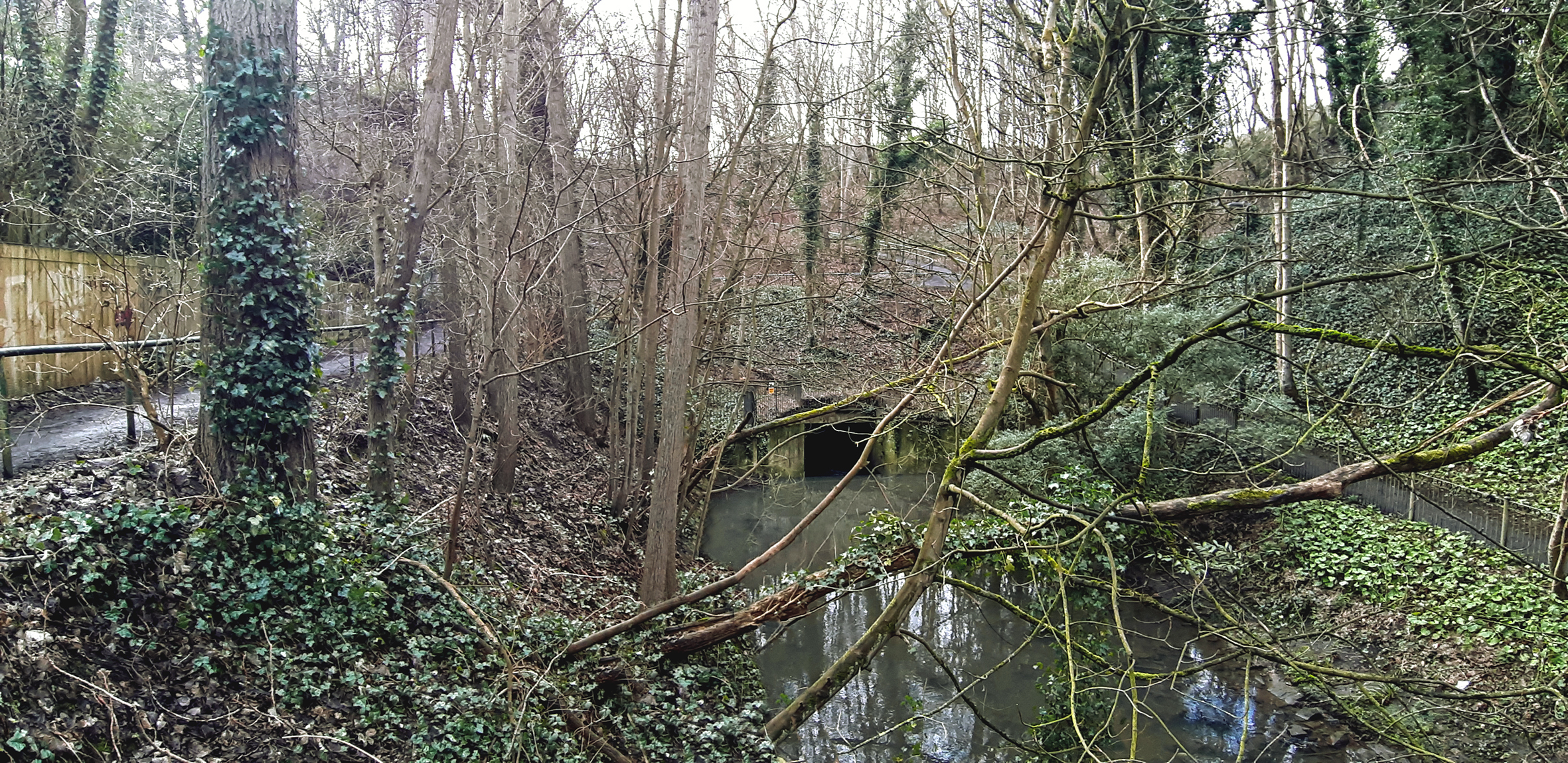
Today’s evidence of the culvert’s existence is decidedly removed from the original construction. When I was a nipper exploring my vast dominion, the entrance to the culvert was mostly unchanged, except for the metal railings preventing access at the Sandyford entrance. You could see the construction but that was all. The exit under Byker Bridge, however looked like this in the early 1960s.

We little lads can find adventure wherever, along with wet shoes, muddy knees and diphtheria.
Now the picture is very different, most evidence of the entrance and exit has been obliterated, except what you see in my 2021 photos.
The first is the Vale.

The south exit is even more inaccessible, which has a lot to do with raves held there around 2017. Ubiquitous graffiti provides further disguise.
Ambitious Plans
With the war over and housebuilding on the tip forbidden, what could be done with the land created by the culverting and levelled by infill? How about a sports stadium? Here’s an ‘Evening Chronicle’ sketch from the 1950s of the plans.

Seating for 86,000 people (Yes, eighty six thousand!) was augmented by a further space for 8,500 standing. Car parking was to be on three floors below the stands. Indoor sports, ice rinks (yes, plural), and badminton courts were also planned. T Dan Smith proposed spending £500,000 to prepare such a stadium for the British Empire Games. (Renamed the British Commonwealth Games by the time 1966, the year he was targeting, came round). ‘The best intentions’ right? We got a wooden hut and a cinder track, plus the grand name.
Build by Numbers
I passed our – so called – City Stadium on an almost daily basis riding the Number 1 or 2 bus to and from town during the ’60s and early ’70s, and remained mystified by the enormous forest of stone blocks, all numbered in white figures, scattered over the near corner of the unrealised City Stadium. It turned out they were the Royal Arcade waiting to be resurrected at some future time and place. I was equally mystified by their disappearance sometime during the ’70s; at least I assume it was then because I was in and out of Newcastle throughout that decade and was gone almost for good by the ’80s: just like the Royal Arcade, the prestigious City Stadium and our Empire!
Now, if you drop by ‘the tip’ you’ll see the unmistakeable signs of gentrification, the most recent phase of the rich history of this patch of Heaton. What went before has almost, but not quite, been forgotten. But should we be making more of our heritage? The Victoria Tunnel has become a tourist attraction. Perhaps I’m biased but I reckon the City Stadium and Ouseburn Culvert has an even more exciting history. Conducted tours anyone?’

Acknowledgements
Researched and written by Keith Fisher, Heaton History Group. Thank you to Carlton Reid for information about the washing tubs.’ Photograph of the Victoria Tunnel courtesy of ‘The Evening Chronicle’.
Can You Help?
If you know more this part of Heaton or have memories or photos to share, we’d love to hear from you. You can contact us either through this website by clicking on the link immediately below the article title or by emailing chris.jackson@heatonhistorygroup.org
Sources
The author’s personal archives
‘The Ouseburn Culvert and the City Stadium’ by Marian Jones; ‘The Newsletter of the Ouseburn Trust Heritage Group’, Spring 2008.
‘Bridging the Ouseburn’ by Sue Bright; Ancestors Publishing, 2013
Originally published on 24/04/2021
Enjoyed reading your article Keith. Maybe the only clue today, of the existence of the West Heaton Brickworks, is the Brickworks Studio in Hannington Street, Byker. Did a walk around the City Stadium track this morning. Arthur
Excellent article, thanks – I thought I was well-versed in the Culvert’s history, but there’s numerous details here I was unaware of.
Fascinating read. I lived in Dinsdale Road just off Starbeck Avenue from 1964-2000 and know this area well but never knew about the levelling of the tip and how Heaton became connected to Sandyford and on to the city centre. As a child we referred to the stadium as ‘the tip’ but it wasn’t the thoroughfare that it is today. I do remember marching bands practicing there though and for us kids living in the terraces with only back yards, the open expanse of grass was a great playground.
Thoroughly well researched and a brilliant read thank you.